
Dawn of the Savage Twin

Femundsmarka, Norway

11–17 January

7 days

8 guests + 2 guides

Multi-day ski touring experience required

18+ yrs

25,500 SEK
Leveling up your winter expedition skills.
You’ve already done a multi-day ski touring trip and feel ready to take it up a notch? Our Level 2 is five days of winter camping in unknown terrain. Researched of course, but unknown. As new to our guides as it is to you. We do just one every year – a new location each time. A true expedition in every sense of the word!
Not just tagging along anymore.
This a stepping stone to independent expeditions in the snow! We’re heading into proper wilderness – no trails, no huts, nothing man-made at all. You’ll participate in the planning, learn to navigate a completely new terrain and assess safety. You and your tent buddy are a team within the team. Each duo gets the chance to "lead" the expedition for one day, with helpful advice of course.
2026: Dawn of the Savage Twin
We’re heading to Femundsmarka National Park in Norway. Otter slides along rapids and narrows. A sunrise trek on Stor-Svuku’s ridges for fresh wolverine tracks. Frozen basins and narrow lake corridors stitched together in an endless maze. Femundsmarka is indeed stark country – harsher, richer in wildlife, and more Arctic in feel than its Swedish twin, Rogen, across the border. Last year we skied Rogen. This year, we meet its fiercer twin!
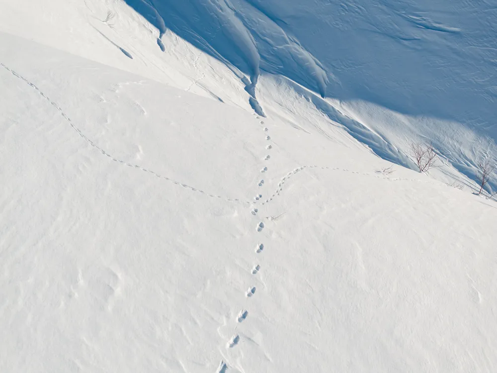
Wolverine tracks on the ridges.
The Femundsmarka–Rogen borderland is home to one of Scandinavia’s densest wolverine populations, and Stor-Svuku’s ridges are prime territory. At dawn we ditch the sleds and ski toward the 1,000 m shoulder – their tracks are sharpest then, before drifting snow covers them. From there the panorama unfolds – the frozen basins of Roasten to the east, the Røa lakes winding west, and the white dome of Sølen to the south.
Roasten and the Røa Corridor
The Roasten lake system is expansive and open – a frozen highway where we ski straight across broad basins with the Stor-Svuku massif always in view. Røa is the opposite. A thin chain of lakes strung together by rapids, like a natural hallway through otherwise tangled terrain. Even in deep winter, the current leaves pockets of open water. Otters thrive here, belly-sliding down banks and diving where the surface stays free. Reindeer herds also cross the corridor …and with them come predators – wolverine, lynx, and ravens circling above.
Youths: –1,000 SEK
Deposit: 1,000 SEK at the time of booking
* Pay in full before March 31st
** 7 people or more


Deposit: 1,000 SEK at the time of booking
Pure adventure and learning winter skills
This tour is about being true explorers, while learning the skills to explore safely in unknown winter terrain. We incorporate a learning curve towards the knowledge and confidence to eventually go it alone without guides.

5 days of ski touring and winter camping
First and last nights' accommodation in cabin near location
Learn from fun and experienced guides
Top quality gear
Breakfast, lunch, snacks and dinners
Return transfer Mora
Dates
11-17 January (2026, tour has been completed)
10-16 January (2027, location to be determined, bookable now)
Transfer times
Pickup: 13:40 at Mora train stn
Dropoff: 12:00 at Mora train stn
Prerequisites
Age limit, 18 years
Winter Adventure in Northern Dalarna or another multi-day trip on touring skis.
Unsure if experienced enough, send us an email please.
Payment
1,000 SEK deposit per person at the time of booking, remaining balance due 6 weeks prior to your departure.
Cancellations
Full refund up until 6 weeks prior to your departure. 50% refund up until 3 weeks prior. No refund less than 3 weeks prior.
Accommodation
Shared twin rooms in cabin.
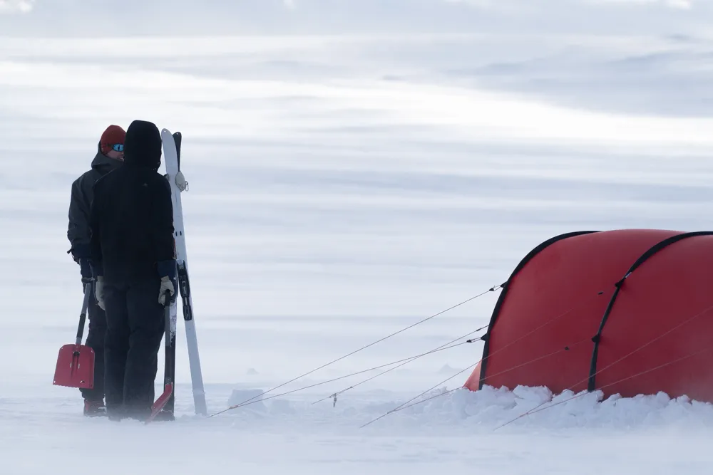
Shared Hilleberg Keron 3 GT tents during expedition.
Dietary restrictions
Just let us know well in advance and we'll sort it out.
Useful Links
We spend the first and last nights at our cabin by Lake Navar, and in between – a glorious 5-day winter camping expedition!
Day 1: Into the forests of silver pine
We leave Elgå on the shore of Femunden, Sølen’s white dome faint in the distance. It’s a steady ski through birch into pine forest at slightly higher ground.
The old pines here are called sølvfuruer – silver pines. Gnarled, weathered, standing wide apart like ancient guardians. Moose leave deep craters in the snow, and reindeer drift past in long trailing lines. The forest is airy and open, every sound carries. A wingbeat, a crack of ice, the crunch under our skis – it all feels magnified.
Elgå (~660 m) → Svukuriset forests (~750 m)
- Distance: 10-12 km
- Elevation gain: +90 m
- Gentle climb out of the birch and into silver pine forest.
Day 2 & 3: Svukuriset – Roasten – the Røa corridor
Roasten and the Røa corridor are the heart of this trip – a dead-ice landscape of basins and ridges carved in the last ice age. In January, it all locks solid, and the lakes turn into natural highways.
We drop into the Roasten basin, skiing across wide frozen lakes with Stor-Svuku looming to the west. On a clear day, the labyrinth of islands makes the skiing feel like weaving through a maze.
Most nights, the ice rests in silence. But sometimes, when the cold snaps or eases, it shifts and groans with a deep rumble that rolls across the basin.
The next morning, we leave our camp behind and ski light into the Røa corridor – a chain of long lakes linked by rapids, a narrow passage through the stark country. This is classic otter ground. They use the inlets and narrows as their playgrounds, sliding belly-first into cracks of open water, leaving smooth tracks like toboggan runs down the banks.
Reindeer wind their way through the corridor, fox and marten leave delicate prints, and if we’re super lucky, lynx. By early afternoon, we’re back to break camp and move closer to Stor-Svuku, where we pitch our tents in the forested lee of the massif.
Svukuriset (~750 m)→ Nedre Roasten (~700 m)
- Distance: 12-15 km
- Elevation change: –50 m
- Descend into the Roasten basin, skiing across wide frozen lakes.
Nedre Roasten (~700 m) → Røa corridor (~720 m), then camp closer
to Stor-Svuku (~800 m)
- Distance: 10-12 km
- Elevation gain: +100 m (spread out over the day)
- Mostly flat lakes, but some gradual climbing when moving camp toward the foot of Stor-Svuku.
Day 4: Up Stor-Svuku in search of wolverine tracks
Stor-Svuku, at 1416 m, is no jagged peak but a massive dome. Its ridges are stripped bare and feel stark, almost Arctic. This is wolverine country, and the mountain’s open slopes are prime ground. They travel at night, covering astonishing distances, and at dawn their trails are freshest, stamped clear across the snow before the wind smooths them away.
We rise before light, strap on our skis and headlamps, and climb to the shoulder at 1,000–1,100 m. We scan for bounding wolverine tracks, and sweep the ridges with the spotting scope. Maybe, just maybe, we’ll even be lucky enough to see one.
Ravens are constant companions here. We watch for them circling above ridges or valleys – a sign that something has passed, a wolverine or lynx leaving scraps behind. Their croaks and rattles carry far, the soundtrack of this wild frontier.
And the view! Roasten lies open to the east, Røa twists west, Sweden’s Rogen ridges glow pale in the distance, Sølen looms to the south, and on a clear day Rondane shimmers to the west.
After the climb we ski on, contouring the massif before dropping back into forest for our last camp.
Dawn trek up Stor-Svuku, then traverse (2–4 km trek + 10–12 km ski)
- Distance: 2-4 km snowshow, 10-12 km ski
- Elevation gain on snowshoe: +200–300 m, then back down.
- After descent: ski traverse ~–50 m into forest for final camp.
Day 5: Back to Femunden
Femunden is a sea of ice, Norway’s third-largest lake. Vast and stark, yet majestic in its openness. At sunset the surface blushes pink, and if the air is clear, Rondane’s distant peaks shimmer on the horizon.
Sleds run smooth downhill as we ski through moose-trampled forest. Perhaps willow ptarmigan burst from snow burrows in flurries of white. At last we break out onto the lake, Elgå small and human at the edge of this endless wild.
Forested camp (~750 m) → Elgå (~660 m)
- Distance: 10-12 km
- Elevation loss: –90 m
- Mostly downhill through forest back to Femunden’s shore.

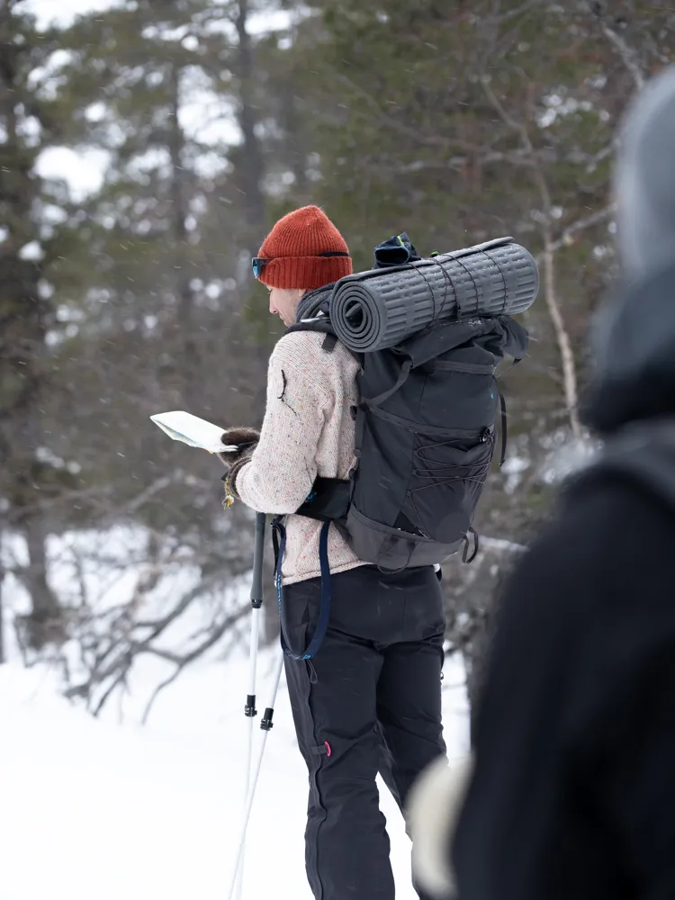
We do the preliminary planning for this tour (in level 3, you’re part of that stage too!) – going over maps, checking gradients and elevation, figuring out a proposed general route, assessing risks. Ahead of the adventure, we’ll have a video meeting with everyone who’s participating to discuss the plan and our trip together.
We split up into tent buddy teams for this one. You and your buddy cook your own meals and melt your own snow. But moreover than practicalities like that, you'll learn how to navigate a completely new snowy terrain and assess safety.
Each duo will lead the expedition during one day (with helpful advice). That means checking the map, especially gradients to take out a good route, figuring out a spot that will likely be good for camping, triangulating compass bearings, assessing energy levels of the team, and taking weather conditions into account.
Us in the winter biz like to say: "A plan is nothing, but planning is everything." What does that paradox actually mean then? Planning is crucial. But once we set off, we gotta be ready to change the plan and make decisions on the fly. We'll both learn as we go along, and discuss potential scenarios in theory.
An obvious one, weather is a biggie. Maybe the weather changes and we're not able to get as far as we planned. Or maybe we actually need to push on to get to a place with enough shelter to camp if it's windy.
Snowed a tonne last night? Breaking trail through deep snow is strenuous as hell. It can be hard to do pulling a sled, and we'll need to repack to make it easier for the person in the front.
What are the energy levels of the group? Maybe we need to adapt the route or repack to make it easier for some.


All you need to know, and then some
We have gathered the most important guides for this trip. If you want to delve deeper, there is more to discover in Guides & Articles.
